
Morphology and dynamics of the Antarctic and Greenland ice sheets
Ice sheets are highly non-linear systems and the only way of determining their response to climate forcing both in the past and the future is with the aid of complex, coupled numerical models. As with most models of environmental systems they have, however, a number of tuneable parameters and are often poorly constrained by observational measurements. Satellite remote sensing provides the only practical means of obtaining extensive coverage over the large areas covered by Antarctica and Greenland. This project aims to address this issue in two key areas: topography and dynamics.
Ice sheet topography is an important parameter in numerical modelling for two reasons. First it can be used to validate the ability of a model to reproduce the present-day geometry. Second, ice flows downhill and the magnitude of the gravitational driving stress that creates this flow is proportional to the surface slope. To accurately reproduce the dynamics of an ice sheet a model must, therefore, accurately reproduce surface slope or use it as an input boundary condition. It is also possible to combine the observed surface slope data with ice mass balance measurements to derive an estimate of a quantity known as the balance velocity. This parameter can also be used either to validate model performance or as an input data set (Bamber et al, 2000b). Furthermore, recent developments in the use of satellite-derived surface topography to derive balance velocities (Bamber et al, 2000a) have provided new insights into the flow characteristics of the East Antarctic Ice Sheet (Figure 1).
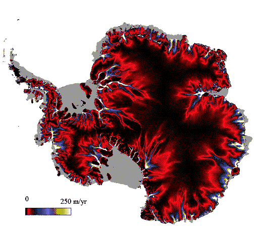
Figure 1. Balance velocities calculated for the whole of the grounded portion of the Antarctic ice sheet.
The primary data set used in this study was derived from ERS-1 radar altimetry. This data set, however, extends to a maximum latitude of only ±81.5°, leaving a large part of central East Antarctica relatively poorly charted.
Interferometer SAR (InSAR) has proved to be a valuable tool for mapping the surface velocity field of ice masses ranging from individual glaciers to almost complete drainage basins of the Greenland and Antarctic ice sheet (e.g. Bamber et al, 2000a). Both balance velocities and InSAR data have proved invaluable in constraining and validating numerical modelling simulations (e.g. Bamber et al, 2000b). Thus, accurate topography and surface velocities have two key roles: i) providing valuable insights into the behaviour of the ice sheets in their own right and ii) as a valuable input to and constraint for numerical models of ice dynamics. The overarching aim of this project is to improve our understanding of the form and flow of the ice sheets with the aid of existing and new developments in satellite technology and missions. This will be closely allied to concurrent projects within CPOM on numerical modelling.
Some of the key objectives of this project are to:
- Use new satellite-derived topography to provide extended coverage of the interior of Antarctica and in the steeper marginal areas of both Greenland and Antarctica.
- Use these improved topographic data sets as an input to, and constraint for numerical models.
- To enhance CPOM SAR and InSAR processing capability, using existing and to-be-acquired SAR data from ERS-1/2, ENVISAT and RADARSAT to investigate the dynamics of the ice sheets in conjunction with numerical modelling activities.
References:
Bamber, J.L., Vaughan, D.G. Joughin, I, 2000a. Widespread complex flow in the interior of the Antarctic Ice Sheet. Science, 287 (5456), 1248-1250.
Bamber, J.L., Hardy, R.J. Huybrechts, P. and Joughin, I., 2000b. A comparison of balance velocities, measured velocities and thermomechanically modelled velocities for the Greenland Ice Sheet. Annals Glaciology, 30, 211 – 216.