CryoSat is an ESA earth explorer mission launched in April 2010, with CPOM Director Andy Shepherd as the Principal Scientific Advisor. Dedicated to measuring polar sea ice thickness and the mass balance of the Greenland and Antarctic ice sheets, CryoSat flies at an altitude of just over 700 km and reaches latitudes of 88° north and south, maximising its coverage of the poles.

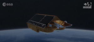
CryoSat-2 seen from underneath. Credit: ESA
CryoSat uses a unique radar instrument called SIRAL (Synthetic Aperture Interferometric Radar Altimeter), specifically designed to measure both sea ice and the polar ice sheets, particularly at their edges where icebergs calve. SIRAL can not only detect tiny variations in the height of the ice but also measure sea level with unprecedented accuracy. The CPOM Near Real-Time (NRT) portal provides more information on CryoSat measurements of sea ice thickness as well as Antarctic ice sheet surface elevation change.
So far, SIRAL has exceeded all expectations, allowing CryoSat to deliver the first complete assessment of Arctic sea ice thickness and volume, as well as the most precise measurements yet of the volume and mass of the Antarctic and Greenland ice sheets.