
By Kate Briggs, CPOM Research Fellow
Shrinking of the Greenland and Antarctic Ice Sheets causes sea levels to rise. I work with satellite data to measure how the mass of these ice sheets is changing.
I have been interested in glaciers as long as I can remember. My dad was a geography teacher and I think I went on my first geography field trip to a glacier around the time I was learning to walk. I’m not sure why, as a child, I was so fascinated by them, maybe it was their size because they were so big, or that they were foreign because we didn’t have them in England, or perhaps it was just because I thought they were really, really beautiful. Whatever it was, they never lost their appeal for me. And so, here I am, some years, some education and some employment later, spending my days researching glaciers and ice sheets, working to improve our understanding of how and why they are changing.
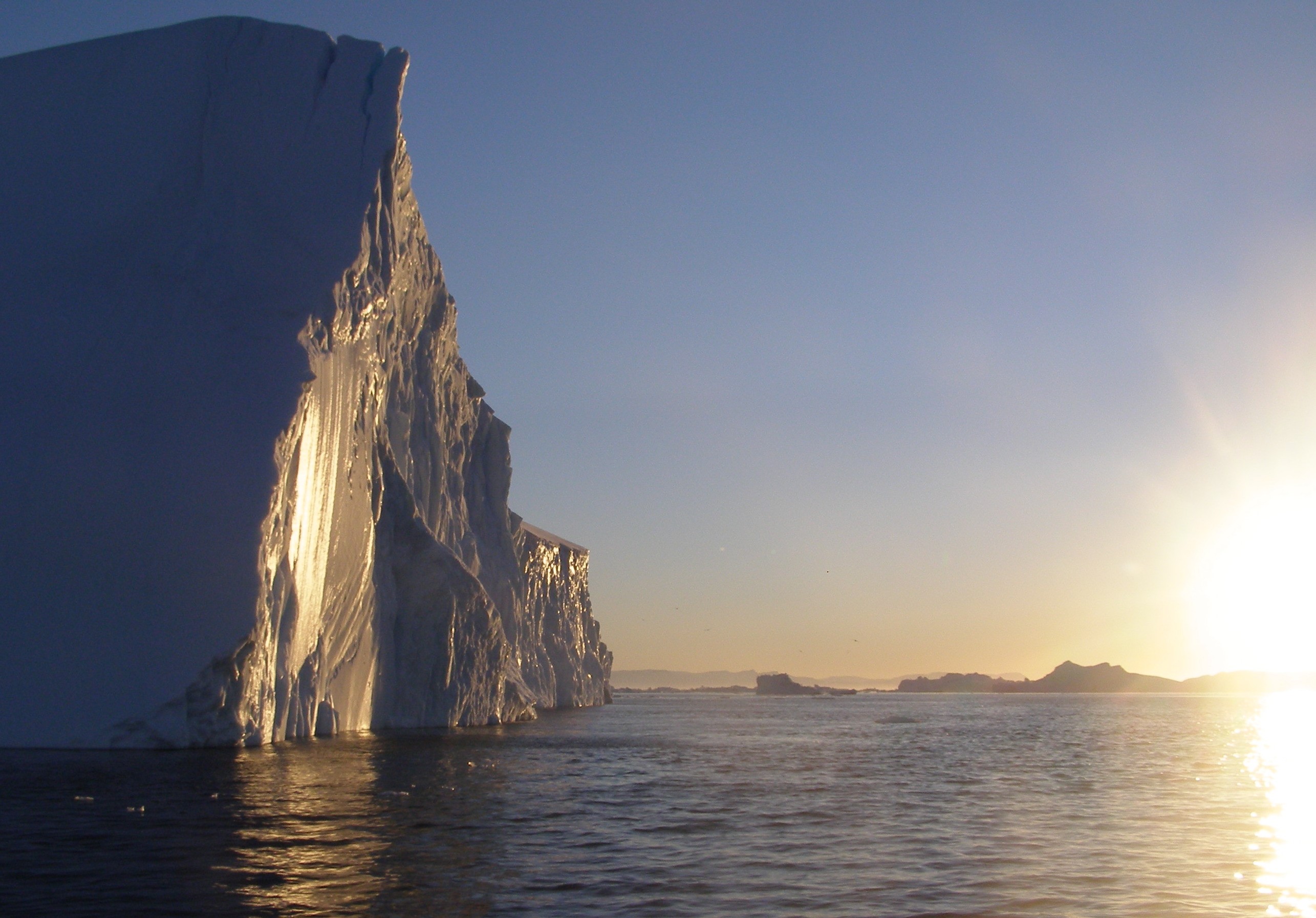
Midnight sun catches a large iceberg in Disko Bay, West Greenland. Credit: K. Briggs
One of the first things I learnt at University was that the ice sheets of Greenland and Antarctica are by no means static; they grow and shrink with changes in the conditions of the atmosphere and the oceans with which they are in contact. For example, around 125 thousand years ago, when air temperatures globally were not that different to those at present, it is estimated that the Greenland Ice Sheet may have been as much as 50% smaller than it is now, contributing 3.5 meters to global sea level (Dutton et al., 2015). It is widely known that we are now in a time when the ice sheets are shrinking and that this is contributing to rising sea levels (IPCC AR5). As a consequence of the inevitable flooding, this has the potential to lead to substantial negative socio-economic impacts in densely populated coastal regions around the world (IPCC AR5). To lessen these impacts we need to be able to predict the magnitude and rate at which the ice sheets will shrink.
Good predictions of ice sheet changes rely on thorough knowledge and understanding of their present-day behavior, and this in turn, depends on accurate observations. To assess the contribution of the ice sheets to sea level rise we measure changes in their mass, and because the ice sheets are so large and remote, the best way to do this is by using data from satellites orbiting in Space.
There are three main ways in which satellites can be used to measure the changing mass of the ice sheets. Firstly, by measuring changes in the height of the surface of the ice sheet through time we can estimate the volume of ice lost or gained. This technique is called altimetry. Second, by measuring the change in the gravitational pull of the ice sheet we can get a direct estimate of the change in the mass of the ice with a technique called gravimetry. Thirdly, by measuring the change in the speed at which the ice is flowing, and combining this with data about the snowfall and melting rates of the ice sheets, we are able to produce a budget of the inputs and outputs of the ice sheets. This is called the Mass Budget, or Input-Output Method.
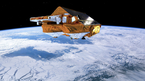
CryoSat-2 altimeter provides measurements of the height of the ice sheet surface. Credit: ESA
The first satellite acquiring data with which we can make ice flow measurements was launched in the 1970’s, followed by altimeters in the 1990’s and a gravimeter in the 2000’s. We now have such data from more than 20 satellites and this has been used by research groups around the world with a common aim of trying to develop the most accurate way of measuring the mass change of the ice sheets. To date, there have been over 150 estimates of ice sheet mass change published in the scientific literature (Briggs et al., 2016).
Just as a journalist or a judge requires information from multiple sources to be sure of a story, repeated measurements from different groups, different methods and different satellites are important for providing scientists with certainty about the changing mass of Greenland and Antarctica. It has been repeatedly shown, with almost complete consistency, that overall the ice sheets have been losing mass over the past few decades of our measurements (see the graph below). However, because of differences in how the measurements are made, there is spread in the estimates that ultimately limits the precision of our assessment of the ice sheet contribution to sea-level rise.
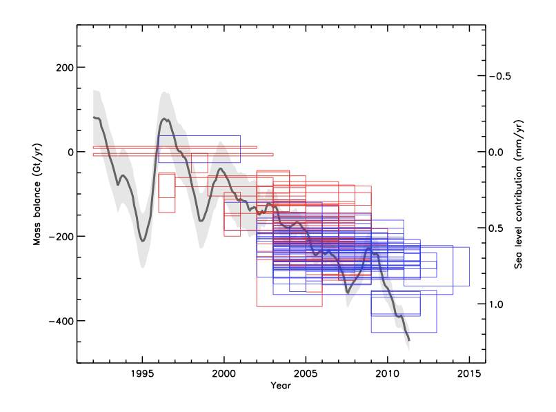
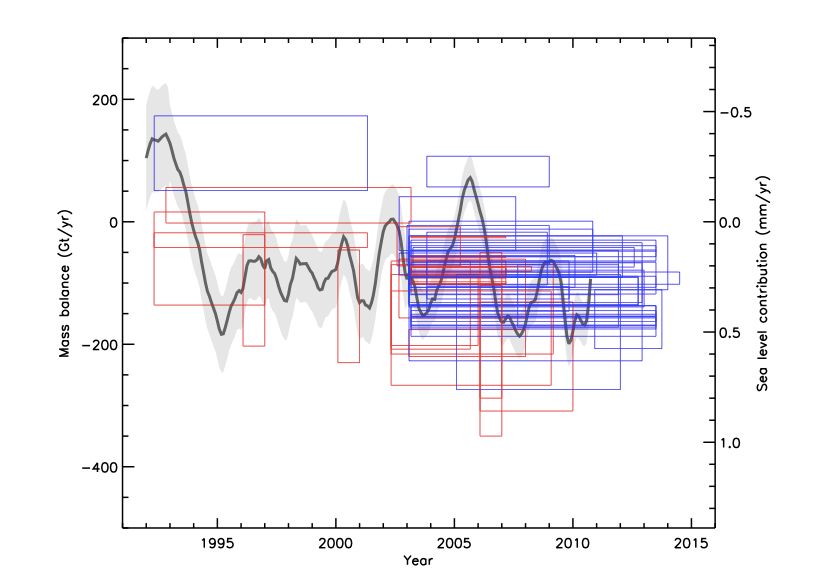
Estimates of Greenland (left) and Antarctic (right) ice-sheet mass changes (mass balance) and sea-level contributions published before (red) and after (blue) the 2012 IMBIE assessment (grey). Credit: Briggs et al., (2016)
To solve this problem, in 2011 a group of 47 scientists from around the world, jointly led by CPOM’s director Andrew Shepherd, got together to compare their methods and results (imbie.org). The aims of the exercise were to understand the reasons for the differences in their estimates and to reach a consensus assessment of ice sheet mass change. By bringing together the results from the different groups and the three different techniques in a set of controlled experiments, the exercise showed that they were in agreement and successfully produced reconciled assessments of Greenland and Antarctic mass change. These assessments showed that between 1992 and 2011, the Antarctic and Greenland ice sheets together lost mass that contributed over 11 mm to global sea-level rise (Shepherd et al., 2012).
The mass of the ice sheets and their contribution to sea level is continually changing through time, and in order to properly understand why they are changing, we need long-term records. For these reasons it is important that we are able to keep our measurements up-to-date. Four years have past since the last consensus estimate of ice sheet mass change and so, it is now time to repeat the exercise. Preparations for a second assessment have been underway for several months and there is currently an open call for data (imbie.org). Any scientist producing relevant estimates is invited to take part, and submit their contributions by the end of September 2016. These estimates will then be compared, analysed and combined to produce the next, up-to-date consensus mass change measurements that are due for release in early 2017.
If you would like to get further information on the exercise or you would like to take part, please visit the IMBIE website.