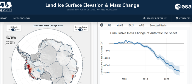
Animation: A visualization of the Land Ice Portal, credit: CPOM
Since the launch of Earth Observation satellite missions, the information we have on ice on Earth has taken a significant leap forward. We can now monitor Earth’s ice without having to go to the poles, but despite this incredible step forward in technology, it is still challenging for scientists to process and interpret the data we acquire from satellite missions.
CPOM’s new land ice portal provides a renewed and improved public access visualization tool for CPOM’s ice sheet monitoring products.
Currently covering Antarctica, with Greenland due to be added shortly, it monitors mass and surface elevation change of the ice sheets, derived from European radar altimetry missions. The data currently spans 1995 to the present, drawing on three European Space Agency (ESA) missions: ERS-2, Envisat, and CryoSat-2, with NASA’s ICESat-2 used for validation purposes.
Processing raw altimetry data is a complex task that CPOM has been developing expertise in for over 20 years. Creating accessible portals saves users significant time and effort by providing high-level elevation and mass change products needed for their research.
The portal supports:
Ice sheet mass balance & sea-level assessment
Elevation-change data underpins the periodic community mass-balance reconciliation exercises (IMBIE), which combine altimetry, gravimetry, and input-output method estimates into the data used in IPCC assessments.
Model initialisation and validation dynamical ice sheet models
BISICLES (used in the UK Earth System Model) and the ISMIP6 model intercomparison use observed elevation/mass trends as boundary conditions and validation targets for future sea-level projections.
Regional/basin studies of specific dynamic imbalance such as Pine Island, Thwaites grounding-line retreat and key areas of Antarctic research.
The portal is designed with enhanced accessibility for users in mind, and offers a quick, straightforward data download function covering 1995–2026, in multiple formats, including uncertainty estimates.
The portal offers two main modes of visualization:
- Maps showing surface elevation and mass change across the ice sheets.
- Time series of change for each glaciological drainage basin.
Antarctica is divided into glaciological basins using established polygon definitions developed by various research groups, including critical areas like Pine Island and Thwaites Glacier in West Antarctica, where the majority of mass loss, and therefore sea level contribution, is occurring. Users can view time series for individual basins, for West/East Antarctica and the Antarctic Peninsula as regions, and for Antarctica as a whole.
What’s New Compared to the Previous Portal?
- Combined mass and elevation change: for the first time, both are available on the same portal (previously only surface elevation change was included). Mass change is particularly important for understanding sea level impacts and deriving it from elevation data involves complex processing.
- CF compliance: products are now fully compliant with the Climate and Forecasting metadata standard, making the data easier to use.
- Cumulative change products: previously only rates of change were provided; now time series of cumulative change is available too, giving users the flexibility to derive their own trends over their period of interest.
- Clickable basin time series: a new interactive feature.
- Cumulative change animations: previously produced in isolated instances, now integrated into a single portal for the first time.
Why Continued Maintenance Matters
Maintaining and improving the portal is an ongoing necessity for several reasons:
- Contemporary observations: the portal is frequently updated with the latest observations, so users get up-to-date information about the health of the ice sheets.
- Evolving input data: the space agencies continuously update and revise the raw altimetry data, so the processing pipeline must adapt accordingly.
- Auxiliary data models: processing relies on auxiliary inputs like firn models (used to account for varying snow density across the ice sheet and how it changes over time), which are also updated regularly and are essential for converting elevation change into mass change.
- Mission transitions: satellite missions themselves change over time. CryoSat-2 is now well beyond its expected operational lifetime, and its successor, CRISTAL, remains on schedule for launch around 2027. New missions bring different data formats and technologies, requiring updated processing methods.
- Cross-calibration: time series from different missions must be continuously cross-calibrated to ensure consistency, which is an ongoing process as new missions come online.
A portal for scientists and policymakers
Turning raw altimetry into elevation and mass change requires decades of expertise due to the need for waveform retracking, cross-calibration between missions, firn/SMB corrections, conversion to mass etc., so without a user-facing portal that expertise doesn’t reach most of the community.
Having one standardised, CF-compliant, version-controlled product means results across research groups are comparable and this makes exercises like the Ice Sheet Mass Balance Inter-comparison Exercise (IMBIE) possible.
The portal not only supports users with visualized and downloadable data for their region of interest, making it comparable to their own data and helps initialise ice sheet models used for sea level projects, but it is also useful for policymakers, who can immediately see the scale of ice mass loss from Antarctica and its implications for global sea levels, with time series making long terms trends clear.
Global temperatures are projected to continue to break records in the coming years according to the WMO. The impact on the polar regions, and the knock-on effect of sea level rise and changes in global weather patterns remain key questions in environmental science. By delivering up-to-date, robust and accessible information on the changing ice sheets, CPOM’s land ice portal supports scientists and policymakers as they seek to answer these questions and plan for a future in a warming climate.
About this work
This work is part of PRESCIENT (UK Polar Research Expertise for Science and Society), a joint National Capability programme between the British Antarctic Survey (BAS) and the UK Centre for Polar Observation and Modelling (CPOM), which supports strategically important long-term measurements and capabilities across four science areas: Polar and Mountain Climate Data Records; Southern Ocean Biological Observatories; Antarctica’s Contribution to Sea-Level Rise; and Space Weather. It also delivers National Public Good by providing independent scientific advice to government, business, and wider society.
Visit the CPOM Land Ice Portal (UCL-hosted website).