AI can map giant icebergs from satellite images 10,000 times faster than humans

AI can map giant icebergs from satellite images 10,000 times faster than humans

Scientists have trained an artificial intelligence (AI) system to accurately map the surface area and outline of giant icebergs captured on satellite images in just one-hundredth of a second.

It is a major advance on existing automated systems which struggle to distinguish icebergs from other features in satellite images. Their findings are published today in leading journal The Cryosphere. Icebergs have a significant impact on the polar environment and monitoring them is critical for both maritime safety and scientific study. They can be extremely large in some cases the size of small countries and can pose a risk to passing ships. As they melt, icebergs release nutrients and freshwater into the seas, and this can have an impact on marine ecosystems.

The study was led by Dr Anne Braakmann-Folgmann at the Centre for Polar Observation and Modelling, which recently moved to Northumbria University from the University of Leeds. Using an algorithm called U-net a type of neural network Dr Braakmann-Folgmann and her colleagues trained a computer to accurately map the outline of icebergs from images taken by Sentinel-1 satellites operated by the European Space Agency. Although manual or human interpretation of satellite images is more accurate, it can take several minutes to accurately outline a single iceberg. If that has to be repeated numerous times, the process quickly becomes time-consuming and laborious.

The algorithm uses an approach designed for manipulating images. By analysing the pixels in the image, it can determine the boundary or outline of objects, in this case it is identifying the outline of the iceberg.

The team also compared the effectiveness of the U-net algorithm to two other state-of-the-art algorithms currently used to map icebergs, known as k-means and Otsu, and programmed them to identify the biggest iceberg in a series of satellite images. They tested all three algorithms on satellite images of seven huge icebergs, which were all between 54km2 and 1052km2. This equates to the icebergs being the same size as the city of Bern in Switzerland and Hong Kong. Up to 46 images of each iceberg were used that were taken over a six-year period. Over a series of tests, the U-net algorithm clearly outperformed both k-means and Otsu and was more effective in delineating the outline of an iceberg.

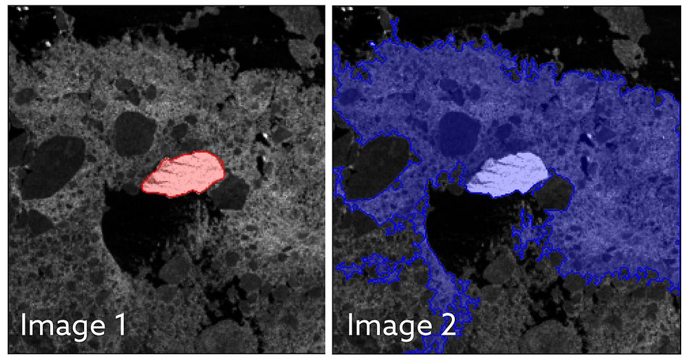
Image 1 shows the U-net algorithm correctly identifying the iceberg, which is surrounded by sea ice. The iceberg is highlighted in red. However, in image 2, the k-means algorithm has identified the iceberg and the sea ice as a single iceberg. It is unable to differentiate between the two, despite them being distinct objects, where sea ice is rather flat ice on the sea and an iceberg standing metres above it. U-net showed an average of a 5% lower estimate of the area of an iceberg, whereas the k-means and Otsu algorithms returned average figures for iceberg area that were between 150% to 170% too large. It is believed that these algorithms were including sea ice and even nearby coastline in their calculations.

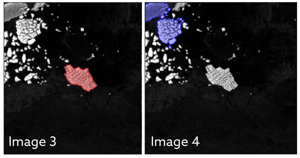
Image 3 shows shows the U-net algorithm correctly identifying the iceberg, which is highlighted in red. However, in image 4 you can see that the k-means algorithm has incorrectly identified a cluster of smaller icebergs and ice fragments, shown in blue, as one large iceberg. Professor Andrew Shepherd, Director of the Centre for Polar Observation and Modelling and Head of the Department of Geography and Environmental Sciences at Northumbria University was one of the co-authors of the study. He said: “This study shows that machine learning will enable scientists to monitor remote and inaccessible parts of the world in almost real-time. And with machine learning, the algorithm will become more accurate as it learns from errors in the way it interprets a satellite image. Dr Braakmann-Folgmann said the technology could result in new services which provide information about the shape and size of giant icebergs. Current mapping services show only the midpoint or central location and length of icebergs. Interpretation by this new approach means their outline and area can be calculated. Icebergs exist in hard-to-reach parts of the world and satellites are not only a fantastic tool to observe where they are, they can help scientists understand the process of how they melt and eventually begin to break apart. Being able to automatically map iceberg extent with enhanced speed and accuracy paves the way for an operational service providing iceberg outlines on a regular, automated basis. Combining them with measurements of iceberg thickness, also enables scientists to monitor where giant icebergs are releasing vast quantities of freshwater into the oceans. The paper Mapping the extent of giant Antarctic icebergs with Deep Learning is published in The Cryosphere. Northumbria University is home to one of the world’s leading groups in the studies of the interactions between ice sheets and oceans. The team of researchers are working to explore the future of ice sheets and glaciers worldwide in a warming world. This involves understanding the causes of ongoing changes in Antarctica, Greenland and alpine areas, as well as assessing future changes and resulting impacts on human environments globally. The University was recently awarded £9 million to become a Centre for Doctoral Training in Artificial Intelligence. The funding from UK Research and Innovation will see Northumbria specialising in citizen-centred artificial intelligence, focusing on the inclusion of citizens in the design and evaluation of AI, helping to ensure this rapidly advancing technology works for everyone.

Northumbria University Press Release: AI can map giant icebergs from satellite images 10,000 times faster than humans | Northumbria University, Newcastle (mynewsdesk.com)

ESA:ESA – AI maps icebergs 10,000 times faster than humans

Satellites now get full-year view of Arctic sea-ice

Satellites can now measure the thickness of Arctic sea ice in the summer months for the first time, thanks to a new study involving UCL researchers and CPOM associates, Professor Julienne Stroeve and Dr Michel Tsamados.

Until now, satellites could only measure sea ice thickness between October and March, when the ice and snow are cold and dry. In the warmer months, melt ponds on top of the ice floes confused the instruments, which could not be used to distinguish between melted ice on an ice floe and the ocean.

In the new study, published in the journal Nature, researchers used an artificial intelligence technique to correct this problem, in which an algorithm was trained on thousands of simulations of satellite data to reliably distinguish between melt ponds and the ocean.

Click here to view the UCL full article.

£47m to address critical environmental challenges facing the UK

The UKRI have awarded £47M to NERC research centres to address six critical environmental science challenges facing the UK, including climate change mitigation strategies, coastal flooding & erosion, and extreme weather.

CPOM is to collaborate on 3 projects BIOPOLE, CANARI & TerraFIRMA.


Biogeochemical processes and ecosystem function in a changing polar system (BIOPOLE), £9 million

Led by the British Antarctic Survey, in collaboration with:

  • British Geological Survey
  • Centre for Polar Observation and Modelling
  • National Oceanography Centre
  • UK Centre for Ecology & Hydrology.

Project partners include:

  • Alfred Wegener Institute, Germany
  • Helmholtz Centre for Polar and Marine Research, Germany
  • University of Alaska Fairbanks, USA
  • University of Alberta, Canada
  • University of Bristol, UK
  • University Centre in Svalbard, Norway.

Climate change is proceeding faster at the poles than any other region, resulting in sea ice loss and glacial melting.

There is a clear urgency in understanding the full implications of these changes for the polar regions themselves and for the wider Earth system.

BIOPOLE will provide a step change in the knowledge and predictive capability concerning how polar ecosystems regulate the chemical balance of the world’s oceans and, through it, their effect on global fish stocks and carbon storage.


Climate change in the Arctic-North Atlantic region and impact on the UK (CANARI), £12 million

Led by the National Centre for Atmospheric Science, in collaboration with:

  • British Antarctic Survey
  • British Geological Survey
  • Centre for Polar Observation and Modelling
  • National Centre for Earth Observation
  • National Oceanography Centre
  • UK Centre for Ecology & Hydrology.

The project partner is the Met Office Hadley Centre, UK.

The weather and climate of the UK is shaped by the large-scale circulation of the atmosphere and ocean in the North Atlantic.

This project will advance understanding of the impacts on the UK arising from climate variability and change in the Arctic-North Atlantic region. It will focus on extreme weather and the potential for rapid, disruptive change.

This will enable the UK to play an internationally leading role in addressing the challenges of understanding regional climate change and provide detailed information about impacts on the UK.


Future impacts risks and mitigation actions (TerraFIRMA), £9.5 million

Led by the National Centre for Atmospheric Science, in collaboration with:

  • British Antarctic Survey
  • British Geological Survey
  • Centre for Polar Observation and Modelling
  • National Centre for Earth Observation
  • National Oceanography Centre
  • Plymouth Marine Laboratory
  • UK Centre for Ecology & Hydrology.

Project partner is the Met Office Hadley Centre, UK.

This project will provide reliable guidance on the risks and impacts of future climate change. It will assess a range of mitigation strategies:

  • impacts on allowable carbon budgets and pathways to net zero
  • wider environmental, economic and societal impacts, for example, sustainable development goals
  • co-benefits, for example, air quality.

The full details can be found at: £47m to address critical environmental challenges facing the UK UKRI

New CryoSat-2 Thematic Products

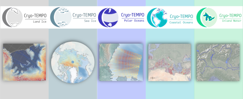
As of January 2022, ESA has started releasing new CryoSat-2 Thematic Products, dedicated to five distinct areas: Sea Ice, Land Ice, Polar Oceans, Coastal Oceans and Inland Waters.

Developed within the frame of the CryoSat-2 Thematic Products (Cryo-TEMPO) activity, these products benefit from agile and state-of-the-art altimetry processing workflows, which utilise dedicated processing for each domain and optimise data fidelity across each thematic surface.

The simplified format and inclusion of fully traceable uncertainties are designed to make CryoSat-2 datasets accessible to new communities of scientific and service users, who traditionally may have lacked the technical expertise required to utilise previous products. To ensure this, a group of thematic non-altimetry experts has been integral in testing and providing feedback on the prototype datasets during the product design stage.

The products were developed by the Cryo-TEMPO consortium led by the UK Centre for Polar Observation & Modelling (CPOM), and the Lancaster University-UKCEH Centre of Excellence in Environmental Data Science (CEEDS).

The current product release represents the culmination of Phase 1 of the Cryo-TEMPO activities, which began in October 2020. The consortium is now working on algorithm evolutions for the next product release, which is scheduled for the beginning of 2023.

The new Cryo-TEMPO product files are distributed via ESA’s CryoSat-2 Science Server and cover the full duration of the CryoSat-2 mission, from 2010 to the present day.

Interested users can access the associated documentation on ESA’s Earth Online website. Further information can also be found on the project website.

Dr Rosemary Willatt Awarded the Konrad Steffen Award

In October, Rosemary Willatt was awarded the Konrad Steffen Award at the ESA Polar Science Week conference, for the best e-poster by an early career scientist. She received a scale model of the Sentinel-1 satellite and 1000 towards publication costs.

Professor Konrad Steffen was Director of WSL, the Swiss Federal Institute for Forest, Snow and Landscape Research, and previously director of the University of Colorado’s Cooperative Institute for Research in Environmental Sciences (CIRES.) He was a lead author on the IPCC’s Special Report on the Ocean and Cryosphere in a Changing Climate and its Fifth Assessment Report. He died in August 2020, aged 68, while conducting fieldwork on the Greenland ice sheet.

Rosie is a Research Fellow at UCL’s Department of Earth Sciences, in the Centre for Polar Observation and Modelling (CPOM) where she is analysing data Ku- and Ka-band ground-based radar data from the MOSAiC expedition. Her research interest is understanding radar interaction with snow cover on sea ice, using ground-based instruments to validate and interpret satellite data. Sea ice plays a key role in climate change, and determining the thickness of sea ice and its snow cover are still challenging due to their remote locations and their physical and electromagnetic characteristics. The MOSAiC Expedition’s data indicate that the polarisation, as well as the frequency, of the radiation, may reveal important information for determining the thicknesses of the snow and ice. The next step is to understand what can be achieved using satellite data which is gathered on much larger scales. Rosie is extremely proud to receive this award for her scientific work, especially having returned to science just over a year ago as a parent of young children, to work in a fantastic team led by Professor Julienne Stroeve – whose advisor was Konrad Steffen.

You can watch the award presentation and learn more about Rosie’s scientific findings here: https://livestream.com/accounts/362/events/9362838.