New research states that future rises in sea level could be better estimated by gaining a clearer understanding of the Antarctic and Greenland ice sheets.
Global climate change and its impact on sea levels is a pressing issue and trying to accurately predict just how much they will rise in future is subject to ongoing analysis. The changing nature of ice sheets is a vital factor in the projection of future sea level rise.
Led by the University of Lincoln and involving Dr Sammie Buzzard from the Centre for Polar Observation and Modelling (Northumbria University), the paper was published today in the Nature journal, Nature Reviews Earth & Environment.
An important aspect of the review highlights that short-term fluctuations in climate could have an amplification feedback effect, meaning that ice sheets are more sensitive to climate change than previously understood.
Scientists have trained an artificial intelligence (AI) system to accurately map the surface area and outline of giant icebergs captured on satellite images in just one-hundredth of a second.
It is a major advance on existing automated systems which struggle to distinguish icebergs from other features in satellite images. Their findings are published today in leading journal The Cryosphere. Icebergs have a significant impact on the polar environment and monitoring them is critical for both maritime safety and scientific study. They can be extremely large in some cases the size of small countries and can pose a risk to passing ships. As they melt, icebergs release nutrients and freshwater into the seas, and this can have an impact on marine ecosystems.
The study was led by Dr Anne Braakmann-Folgmann at the Centre for Polar Observation and Modelling, which recently moved to Northumbria University from the University of Leeds. Using an algorithm called U-net a type of neural network Dr Braakmann-Folgmann and her colleagues trained a computer to accurately map the outline of icebergs from images taken by Sentinel-1 satellites operated by the European Space Agency. Although manual or human interpretation of satellite images is more accurate, it can take several minutes to accurately outline a single iceberg. If that has to be repeated numerous times, the process quickly becomes time-consuming and laborious.
The algorithm uses an approach designed for manipulating images. By analysing the pixels in the image, it can determine the boundary or outline of objects, in this case it is identifying the outline of the iceberg.
The team also compared the effectiveness of the U-net algorithm to two other state-of-the-art algorithms currently used to map icebergs, known as k-means and Otsu, and programmed them to identify the biggest iceberg in a series of satellite images. They tested all three algorithms on satellite images of seven huge icebergs, which were all between 54km2 and 1052km2. This equates to the icebergs being the same size as the city of Bern in Switzerland and Hong Kong. Up to 46 images of each iceberg were used that were taken over a six-year period. Over a series of tests, the U-net algorithm clearly outperformed both k-means and Otsu and was more effective in delineating the outline of an iceberg.
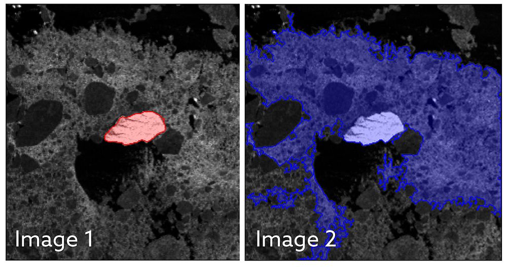
Image 1 shows the U-net algorithm correctly identifying the iceberg, which is surrounded by sea ice. The iceberg is highlighted in red. However, in image 2, the k-means algorithm has identified the iceberg and the sea ice as a single iceberg. It is unable to differentiate between the two, despite them being distinct objects, where sea ice is rather flat ice on the sea and an iceberg standing metres above it. U-net showed an average of a 5% lower estimate of the area of an iceberg, whereas the k-means and Otsu algorithms returned average figures for iceberg area that were between 150% to 170% too large. It is believed that these algorithms were including sea ice and even nearby coastline in their calculations.
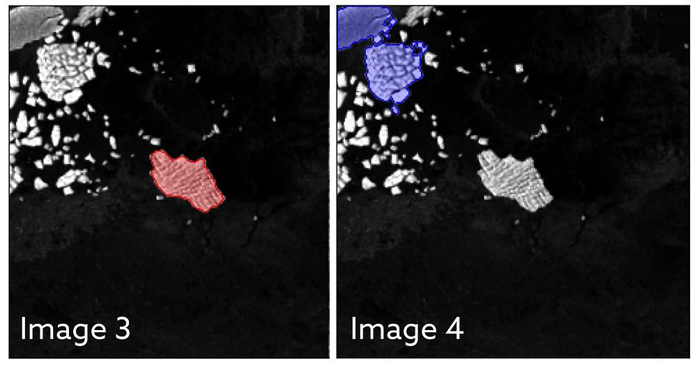
Image 3 shows shows the U-net algorithm correctly identifying the iceberg, which is highlighted in red. However, in image 4 you can see that the k-means algorithm has incorrectly identified a cluster of smaller icebergs and ice fragments, shown in blue, as one large iceberg. Professor Andrew Shepherd, Director of the Centre for Polar Observation and Modelling and Head of the Department of Geography and Environmental Sciences at Northumbria University was one of the co-authors of the study. He said: “This study shows that machine learning will enable scientists to monitor remote and inaccessible parts of the world in almost real-time. And with machine learning, the algorithm will become more accurate as it learns from errors in the way it interprets a satellite image. Dr Braakmann-Folgmann said the technology could result in new services which provide information about the shape and size of giant icebergs. Current mapping services show only the midpoint or central location and length of icebergs. Interpretation by this new approach means their outline and area can be calculated. Icebergs exist in hard-to-reach parts of the world and satellites are not only a fantastic tool to observe where they are, they can help scientists understand the process of how they melt and eventually begin to break apart. Being able to automatically map iceberg extent with enhanced speed and accuracy paves the way for an operational service providing iceberg outlines on a regular, automated basis. Combining them with measurements of iceberg thickness, also enables scientists to monitor where giant icebergs are releasing vast quantities of freshwater into the oceans. The paper Mapping the extent of giant Antarctic icebergs with Deep Learning is published in The Cryosphere. Northumbria University is home to one of the world’s leading groups in the studies of the interactions between ice sheets and oceans. The team of researchers are working to explore the future of ice sheets and glaciers worldwide in a warming world. This involves understanding the causes of ongoing changes in Antarctica, Greenland and alpine areas, as well as assessing future changes and resulting impacts on human environments globally. The University was recently awarded £9 million to become a Centre for Doctoral Training in Artificial Intelligence. The funding from UK Research and Innovation will see Northumbria specialising in citizen-centred artificial intelligence, focusing on the inclusion of citizens in the design and evaluation of AI, helping to ensure this rapidly advancing technology works for everyone.
The seven worst years for polar ice sheets melting and losing ice have occurred during the past decade, according to new research, with 2019 being the worst year on record.
The melting ice sheets now account for a quarter of all sea level rise a fivefold increase since the 1990’s according to IMBIE, an international team of researchers who have combined 50 satellite surveys of Antarctica and Greenland taken between 1992 and 2020.
Global heating is melting the polar ice sheets, driving up sea levels and coastal flooding around our planet. Ice losses from Greenland and Antarctica can now be reliably measured from space by tracking changes in their volume, gravitational pull, or ice flow. NASA and the European Space Agency (ESA) and awarded funding to the Ice Sheet Mass Balance Intercomparison Exercise (IMBIE) in 2011 to compile the satellite record of polar ice sheet melting. Data collected by the team is widely used by leading organisations, including by the Intergovernmental Panel on Climate Change (IPCC).
In their latest assessment, the IMBIE Team which is led by Northumbria University’sCentre for Polar Observations and Modelling have combined 50 satellite surveys of Antarctica and Greenland to determine their rate of ice melting. They have found that Earth’s polar ice sheets lost 7,560 billion tonnes of ice between 1992 and 2020 equivalent to an ice cube that would be 20 kilometres in height.
The polar ice sheets have together lost ice in every year of the satellite record, and the seven highest melting years have occurred in the past decade.
The satellite records show that 2019 was the record melting year when the ice sheets lost a staggering 612 billion tonnes of ice.
This loss was driven by an Arctic summer heatwave, which led to record melting from Greenland peaking at 444 billion tonnes that year. Antarctica lost 168 billion tonnes of ice the sixth highest on record due to the continued speedup of glaciers in West Antarctica and record melting from the Antarctic Peninsula. The East Antarctic Ice Sheet remained close to a state of balance, as it has throughout the satellite era.
Melting of the polar ice sheets has caused a 21 mm rise in global sea level since 1992, almost two thirds (13.5 mm) of which has originated from Greenland and one third (7.4 mm) from Antarctica.
In the early 1990s, ice sheet melting accounted for only a small fraction (5.6 %) of sea level rise. However, there has been a fivefold increase in melting since then, and they are now responsible for more than a quarter (25.6 %) of all sea level rise. If the ice sheets continue to lose mass at this pace, the IPCC predicts that they will contribute between 148 and 272 mm to global mean-sea level by the end of the century.
After a decade of work we are finally at the stage where we can continuously update our assessments of ice sheet mass balance as there are enough satellites in space monitoring them, which means that people can make use of our findings immediately.
Ice losses from Greenland and Antarctica have rapidly increased over the satellite record and are now a major contributor to sea level rise. Continuously monitoring the ice sheets is critical to predict their future behaviour in a warming world and adapt for the associated risks that coastal communities around the world will face.
This is now the third assessment of ice loss produced by the IMBIE team, due to continued cooperation between the space agencies and the scientific community. The first and second assessments were published in 2012 and 2018/19.
Over the past few years, ESA and NASA have made a dedicated effort to launch new satellite missions capable of monitoring the polar regions. The IMBIE project has taken advantage of these to produce more regular updates, and, for the first time, it is now possible to chart polar ice sheet losses every year.
This third assessment from the IMBIE Team, funded by the ESA and NASA, involved a team of 68 polar scientists from 41 international organisations using measurements from 17 satellite missions, including for the first time from the GRACE-FO gravity mission. Importantly, it brings the records of ice loss from Antarctica and Greenland in line, using the same methods and covering the same period in time. The assessment will now be updated annually to make sure that the scientific community has the very latest estimates of polar ice losses.
Dr Diego Fernandez, Head of Research and Development at ESA, said:
This is another milestone in the IMBIE initiative and represent an example of how scientists can coordinate efforts to assess the evolution of ice sheets from space offering unique and timely information on the magnitude and onset of changes.
The new annual assessments represent a step forward in the way IMBIE will help to monitor these critical regions, where variations have reached a scale where abrupt changes can no longer be excluded.
CPOM scientist, Inès Otosaka features as the guest EGU blogger and talks about the importance of radar altimetry in glaciology for predicting future sea-level rise – a fabulous intro to radar altimetry & satellites.
The following blog was written by Research Fellow, Inès Otosaka based at the University of Leeds.
Last month (December 2022), I went to Antarctica for the first time to conduct some ground experiments over Adelaide Island, located on the western side of the Antarctic Peninsula, as part of the joint ESA CryoVEx/DEFIANT Antarctica campaign.
This campaign aimed to collect a wide range of datasets to investigate drivers of recent Antarctic sea ice changes in the Weddell Sea but also to help interpret differences between land ice height and sea ice thickness retrievals from ESA’s CryoSat-2 radar altimeter and NASA’s ICESat-2 laser altimeter. As part of the CRYO2ICE campaign, CryoSat-2 orbit was recently raised so that CryoSat-2 and ICESat-2 ground tracks coincide in space and time periodically over Antarctica. This campaign was thus a unique opportunity to collect ground and airborne measurements to complement these coincident satellite datasets and better understand the differences between radar and laser data.
This involved sending scientists from the University of Leeds (Andrew Shepherd and myself), from ESA (Isobel Lawrence also a former CPOM colleague), from BAS (Galle Veyssire and Carl Robinson), and from DTU (Sebastian Simonsen) to Antarctica for two weeks to collect these datasets. However, many more colleagues were involved in the preparations ahead of the campaign from the testing of the various instruments to the coordination of the campaign logistics and contributed greatly to the success of this campaign.
CryoVEx/DEFIANT team in the hangar at Rothera (from left to right: Carl Robinson, Sebastian Simonsen, Andrew Shepherd, In’s Otosaka, Isobel Lawrence, and Galle Veyssire)
Andy and I departed from Leeds on 29th November and after travelling more than 13,000 km, we arrived in Punta Arenas at the tip of Chile where we met with the rest of the scientific team. We stayed for four days in Punta Arenas waiting for the weather to clear up for our flight to Antarctica and on 5th December, we finally boarded our plane to Rothera, the British Research Station where we would be based for the next two weeks.
We were greeted with spectacular views of the station on our arrival with lots of icebergs and after a tour of the station, we reviewed our plans for the next few days. While Andy and I were in charge of collecting the ground measurements, Isobel, Galle, Carl, and Sebastian were in charge of collecting the airborne measurements. We spent the first day preparing our kit before going to the field while the airborne team started setting up the DASH-7 for the airborne surveys. The DASH-7 is usually used as a passenger aircraft to transport people between Rothera and Punta Arenas (it had been 25 years since it was last used as a scientific survey plane), which meant that all the seats had to be removed so that racks of instruments could be installed inside the plane instead. The airborne team then flew to the Weddell Sea, trying to follow the CRYO2ICE satellite tracks as closely as possible in time and space, which involved some long hours flying on the DASH-7 monitoring the various instruments to make sure that all the data were being acquired properly.
In the meantime, on the ground, we installed four corner reflectors to be surveyed by the airborne team, which will be used for calibrating the different datasets together after the campaign. These very large metal reflectors are digged 1-meter deep into the snow and set up to be around 2 meters above the ground so they can provide a common reference surface for the radar and laser data.
Installing a corner reflector on Fuchs Ice piedmont, Adelaide Island
We also collected some shallow firn cores around the island to measure the density and stratigraphy of the firn. We are especially interested in the depth of ice lenses that form within the firn as those are the signatures of past melt events and we have seen in Greenland that they change the scattering properties of the firn, which can impact surface heights measurements from CryoSat-2.
Drilling 7-meter deep to collect a firn core on Fuchs Ice piedmont, Adelaide Island
We had great weather conditions during those two weeks, and managed to collect all the measurements we had hoped for thanks to the support of the incredible team working at Rothera research station, including the field guides and pilots that came with us in the field, staff at the hangar, and Maz the science coordinator among many others!
Finally, while we were busy for most days we still managed to find some time to walk around the station and were lucky enough to spot some penguins, seals, and even a pod of orcas! This campaign was a great success and it was incredibly rewarding to see all the work that had been done over the months preceding the actual fieldwork come to fruition. Next, we will be analysing all the data collected, which is another exciting step although it will have to be done from our office desks far from the beautiful scenery of Antarctica!
PhD researcher, Robbie Mallett (UCL) attended COP27 in Sharm El Sheikh, Egypt, with the International Cryosphere Climate Initiative. During the conference he gave talks and appeared on panels in the Cryosphere Pavilion. As well as running the pavilion, the ICCI released the 2022 State of The Cryosphere Report, which Robbie helped to launch to the media and COP participants.
Robbie and the ICCI also campaigned for greater recognition of the cryosphere in COP negotiations. This year the cryosphere was specifically mentioned in the conference’s cover declaration for the first time, and the ICCI coordinated a new multinational coalition, named the Ambition on Melting Ice https://iccinet.org/ambition-on-melting-ice/
The UKRI have awarded £47M to NERC research centres to address six critical environmental science challenges facing the UK, including climate change mitigation strategies, coastal flooding & erosion, and extreme weather.
CPOM is to collaborate on 3 projects BIOPOLE, CANARI & TerraFIRMA.
Biogeochemical processes and ecosystem function in a changing polar system (BIOPOLE), £9 million
Led by the British Antarctic Survey, in collaboration with:
British Geological Survey
Centre for Polar Observation and Modelling
National Oceanography Centre
UK Centre for Ecology & Hydrology.
Project partners include:
Alfred Wegener Institute, Germany
Helmholtz Centre for Polar and Marine Research, Germany
University of Alaska Fairbanks, USA
University of Alberta, Canada
University of Bristol, UK
University Centre in Svalbard, Norway.
Climate change is proceeding faster at the poles than any other region, resulting in sea ice loss and glacial melting.
There is a clear urgency in understanding the full implications of these changes for the polar regions themselves and for the wider Earth system.
BIOPOLE will provide a step change in the knowledge and predictive capability concerning how polar ecosystems regulate the chemical balance of the world’s oceans and, through it, their effect on global fish stocks and carbon storage.
Climate change in the Arctic-North Atlantic region and impact on the UK (CANARI), £12 million
Led by the National Centre for Atmospheric Science, in collaboration with:
British Antarctic Survey
British Geological Survey
Centre for Polar Observation and Modelling
National Centre for Earth Observation
National Oceanography Centre
UK Centre for Ecology & Hydrology.
The project partner is the Met Office Hadley Centre, UK.
The weather and climate of the UK is shaped by the large-scale circulation of the atmosphere and ocean in the North Atlantic.
This project will advance understanding of the impacts on the UK arising from climate variability and change in the Arctic-North Atlantic region. It will focus on extreme weather and the potential for rapid, disruptive change.
This will enable the UK to play an internationally leading role in addressing the challenges of understanding regional climate change and provide detailed information about impacts on the UK.
Future impacts risks and mitigation actions (TerraFIRMA), £9.5 million
Led by the National Centre for Atmospheric Science, in collaboration with:
British Antarctic Survey
British Geological Survey
Centre for Polar Observation and Modelling
National Centre for Earth Observation
National Oceanography Centre
Plymouth Marine Laboratory
UK Centre for Ecology & Hydrology.
Project partner is the Met Office Hadley Centre, UK.
This project will provide reliable guidance on the risks and impacts of future climate change. It will assess a range of mitigation strategies:
impacts on allowable carbon budgets and pathways to net zero
wider environmental, economic and societal impacts, for example, sustainable development goals
Scientists monitoring the giant A68A Antarctic iceberg from space reveal that a huge amount of fresh water was released as it melted around the sub-Antarctic island of South Georgia.
Satellites revealed that 152 billion tonnes of fresh water entered the seas around the sub-Antarctic island of South Georgia when the megaberg A68A melted over 3 months in 2020/2021, according to a new study.
152 billion tonnes of water is equivalent to 20 times the amount of water in Loch Ness or 61 million Olympic sized swimming pools.
In July 2017, the A68A iceberg snapped off the Larsen-C Ice Shelf on the Antarctic Peninsula and began its 3.5 year, 4000 km journey across the Southern Ocean. At 5719 square kilometres quarter the size of Wales , it was the biggest iceberg on Earth when it formed and the sixth largest on record.
Around Christmas 2020, the berg received widespread attention as it drifted worryingly close to South Georgia, raising concerns it could harm the island’s fragile ecosystem.
Their findings show that the berg had melted enough as it drifted to avoid damaging the sea floor around South Georgia. However, a side effect of the melting was the release of a colossal 152 billion tonnes of fresh water in close proximity to the island a disturbance that could have a profound impact on the island’s marine habitat.
Anne Braakmann-Folgmann, a researcher at CPOM and PhD candidate at the University of Leeds School of Earth and Environment, is lead author of the study. She said: This is a huge amount of melt water, and the next thing we want to learn is whether it had a positive or negative impact on the ecosystem around South Georgia.
Because A68A took a common route across the Drake Passage, we hope to learn more about icebergs taking a similar trajectory, and how they influence the polar oceans.
For the first two years of its life, A68A stayed close to Antarctica in the cold waters of the Weddell Sea and experienced little in the way of melting. However, once it began its northwards journey across Drake Passage it travelled through increasingly warm waters and began to melt.
Altogether, the iceberg thinned by 67 metres from its initial 235 m thickness, with the rate of melting rising sharply as the berg drifted in the Scotia Sea around South Georgia.
Laura Gerrish, GIS and mapping specialist at BAS and co-author of the study said A68 was an absolutely fascinating iceberg to track all the way from its creation to its end. Frequent measurements allowed us to follow every move and break-up of the berg as it moved slowly northwards through iceberg alley and into the Scotia Sea where it then gained speed and approached the island of South Georgia very closely.
If an iceberg’s keel is too deep it can get stuck on the sea floor. This can be disruptive in several different ways; the scour marks can destroy fauna, and the berg itself can block ocean currents and predator foraging routes. However, this new study reveals that A68A collided only briefly with the sea floor and broke apart shortly afterwards, making it less of a risk in terms of blockage.
By the time it reached the shallow waters around South Georgia, the iceberg’s keel had reduced to 141 metres below the ocean surface, shallow enough to avoid the seabed which is around 150 metres deep.
Nevertheless, the ecosystem and wildlife around South Georgia will certainly have felt the impact of the colossal iceberg’s visit. When icebergs detach from ice shelves, they drift with the ocean currents and wind while releasing cold fresh meltwater and nutrients as they melt.
This process influences the local ocean circulation and fosters biological production around the iceberg. At its peak, the iceberg was melting at a rate of seven metres per month, and in total it released a staggering 152 billion tonnes of fresh water and nutrients.
The journey of A68A has been charted using observations from five different satellites. The iceberg’s area change was recorded using a combination of Sentinel-1, Sentinel-3, and MODIS imagery. Meanwhile, the iceberg’s thickness change was measured using CryoSat-2 and ICESat-2 altimetry. By combining these measurements, the iceberg’s area, thickness, and volume change were determined.
Tommaso Parrinello, CryoSat Mission Manager at the European Space Agency, said: Our ability to study every move of the iceberg in such detail is thanks to advances in satellite techniques and the use of a variety of measurements. Imaging satellites record the location and shape of the iceberg and data from altimetry missions add a third dimension as they measure the height of surfaces underneath the satellites and can therefore observe how an iceberg melts.
Further information:
Image credit: A68A iceberg approaching the island of South Georgia (14 December 2020). The left hand part of the image are clouds. Credit: MODIS image from NASA Worldview Snapshots.
Observing the Disintegration of the A68A Iceberg from Space is published in Remote Sensing of Environment. The article can be found at https://doi.org/10.1016/j.rse.2021.112855.
For additional information contact University of Leeds press officer Anna Harrison a.harrison@leeds.ac.uk